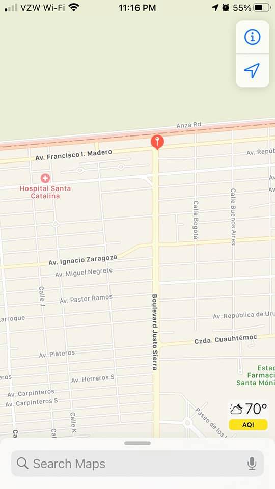
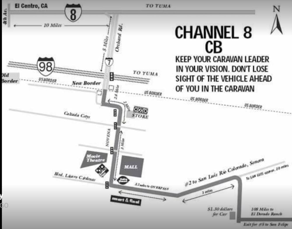
route From Mexicali, San Luis and Los Algodones HWY 5
Page 1 of 1
 Mexicali East border crossing north to USA
mexicali east write-up
https://forums.bajanomad.com/viewthread.php?tid=99285#pid1259208
https://www.discoverbaja.com/wp-content/uploads/Mexicali-East-Border-Crossing.pdf?mibextid=Zxz2cZ&fbclid=IwAR3IUcf2ZtlvG4lHfXkGNdKcgMcDJu9D28d96YeDvfk53NgMElVt3tnuNx0
https://forums.bajanomad.com/viewthread.php?tid=99285#pid1259208
https://www.discoverbaja.com/wp-content/uploads/Mexicali-East-Border-Crossing.pdf?mibextid=Zxz2cZ&fbclid=IwAR3IUcf2ZtlvG4lHfXkGNdKcgMcDJu9D28d96YeDvfk53NgMElVt3tnuNx0
dean- Posts : 5621
Join date : 2008-01-01
 heading north mexicali east
heading north mexicali east
https://www.discoverbaja.com/go/driving-directions/mexicali-east-border-directions/
https://www.discoverbaja.com/go/driving-directions/mexicali-east-border-directions/
dean- Posts : 5621
Join date : 2008-01-01
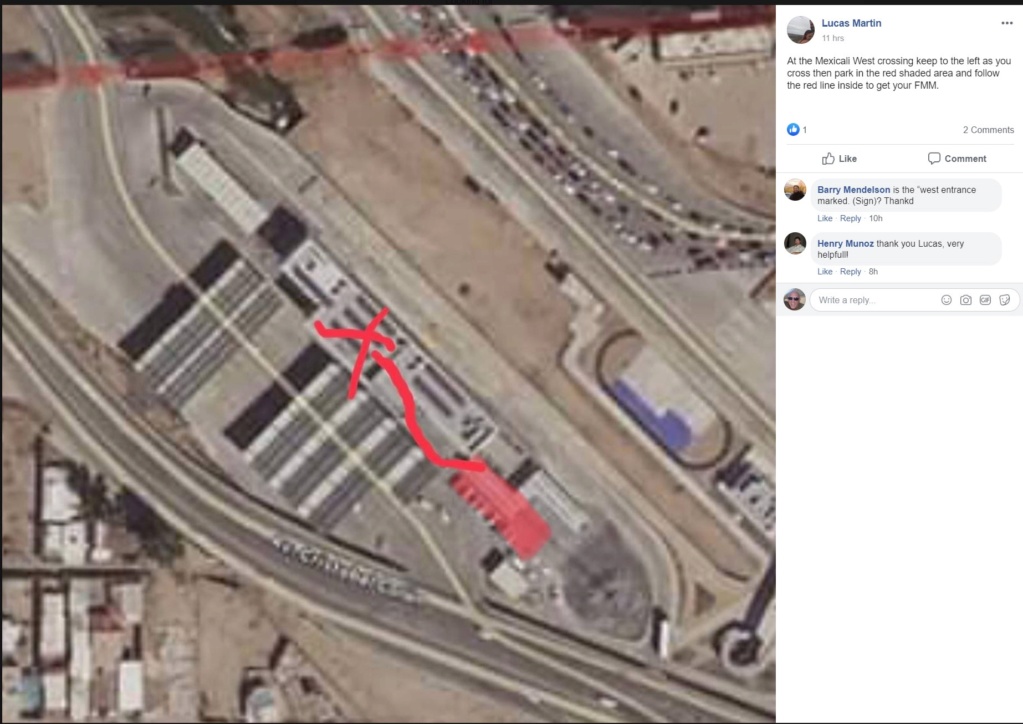
 Mexicali west going south
from facebook
from facebook

from facebook
I just did this in May. As you approach the border, stay LEFT. You will see covered parking and a building on the LEFT. Park in the covered lot and enter the building through the door that is NOT marked immigration. There should be an officer in there, if not he will be there momentarily. I always get my FMM on-line and just get it stamped but easy to get it there, too. Make sure you have your passport.
· Reply · Share · 13h
Mary
, what I tell my family and friends when they come to visit me here south of San Felipe: enter through the fence in the left lane, you will see a covered parking area. Park there, even with towing a trailer, go into the big white building next to the parking area. As you enter the building, turn left and you will see the Immigration agent at a desk. He will do your FMMs for you. Try to have exact change(depends on exchange rate, just don't expect change) It takes 5 minutes, never a line. (Sometimes before 8 am you have to look for an agent, per my adult grand daughter) Get your FMM stamped (pay attention here), leave the building, get in your vehicle and proceed to the Custom Agents! Safe travels!
dean- Posts : 5621
Join date : 2008-01-01
 mexicali east entering mexico immigration
from facebook
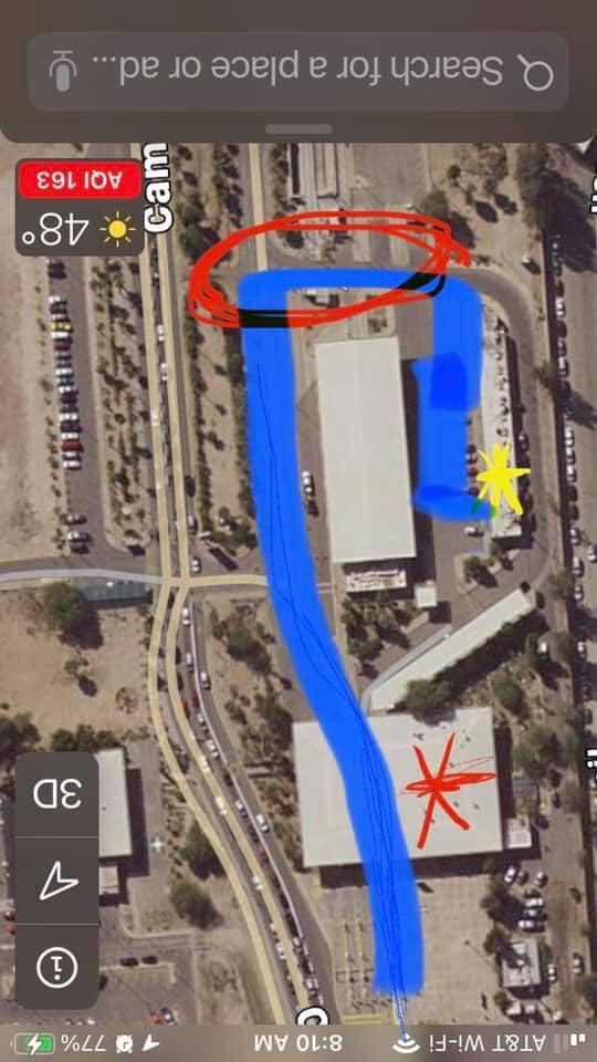
If East crossing is what you choose, the immigration office for your FMM is to the right as you pass through customs. When you get to the guard shack/stop sign, tell the guard you need tourist visa (don't shoot the messenger, I know it's not a visa, but this was the only wording I could use to make him understand). He will move the cone so you can drive around to the right. Park in the lot & walk back to the big building. If you need to pay, the bank is in the small offices in that same parking lot.
Heading south at Calexico East - red asterisk is where INM building is, red circle is guard shack, blue line is route to take, yellow asterisk is where the bank is. Safe travels to all!

dean- Posts : 5621
Join date : 2008-01-01
 Re: route From Mexicali, San Luis and Los Algodones HWY 5
from other forums
http://forums.bajanomad.com/viewthread.php?tid=95465
http://forums.bajanomad.com/viewthread.php?tid=94922#pid1194068
http://forums.bajanomad.com/viewthread.php?tid=95960
http://forums.bajanomad.com/viewthread.php?tid=95465
http://forums.bajanomad.com/viewthread.php?tid=94922#pid1194068
http://forums.bajanomad.com/viewthread.php?tid=95960
dean- Posts : 5621
Join date : 2008-01-01
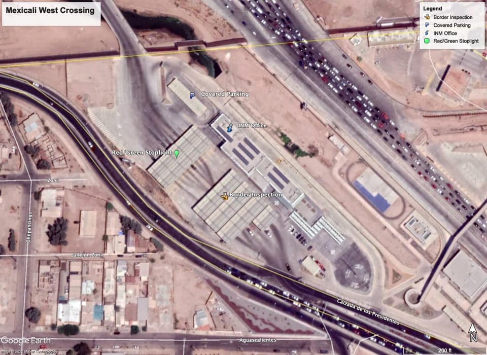
 Mexicali west going south
from facebook
more from facebook,
Where do I get my FMM stamped at the main Mexicali crossing into Mexico?
Is it at this building? - I couldn’t get the map to pull up, however……. If you are heading south through Calexico, aka West port, as you enter the fence area, look to your left. You will see a big white building with covered parking. Drive over there, park, and enter the IMN building. Turn left inside and you will see an agent at the desk. He will do your FMMs for you. About $33 each + or -. You can pay him, best to have correct change. Get back in your vehicle and go through the Customs area. So easy, even with a trailer.
Safe travels.
Park immediately after your inspection. Cross the street to the white building, take the far left door, and the FMM desk is just inside that door, i believe up some stairs.
You can cross west with a trailer. Stay on the left. Don't pull in the parking lot with a big trailer because you can't turn around. Stay far left.
more from facebook,
Where do I get my FMM stamped at the main Mexicali crossing into Mexico?
Is it at this building? - I couldn’t get the map to pull up, however……. If you are heading south through Calexico, aka West port, as you enter the fence area, look to your left. You will see a big white building with covered parking. Drive over there, park, and enter the IMN building. Turn left inside and you will see an agent at the desk. He will do your FMMs for you. About $33 each + or -. You can pay him, best to have correct change. Get back in your vehicle and go through the Customs area. So easy, even with a trailer.
Safe travels.
Park immediately after your inspection. Cross the street to the white building, take the far left door, and the FMM desk is just inside that door, i believe up some stairs.
Last edited by dean on Sat Sep 18, 2021 12:00 pm; edited 1 time in total
dean- Posts : 5621
Join date : 2008-01-01
 heading north Mexicali west
from facebook
https://web.facebook.com/groups/BajaRoads
[b]
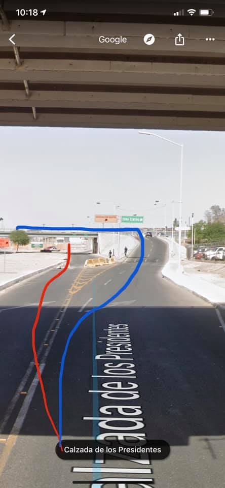
Sooo from rio, the road that goes to Sentri, exit to the right just passing the first bridge. Then it goes up, then take a left. Stick to the right (as if you’re going west) and then a few streets down, you can enter the regular. Stick to the right again and do the loop, you’re there.
If you go straight at rio, passing under BOTH bridges, you’ll hit sentri and get fined.
Blue line is regular.
Orange is sentri.
under = bad
Chuck
yes you nailed it here. I see that fork. If you don't take the blue line, you are blocked in due to concrete barriers.
Christian it’s confusing, but once you do find it, it’s easy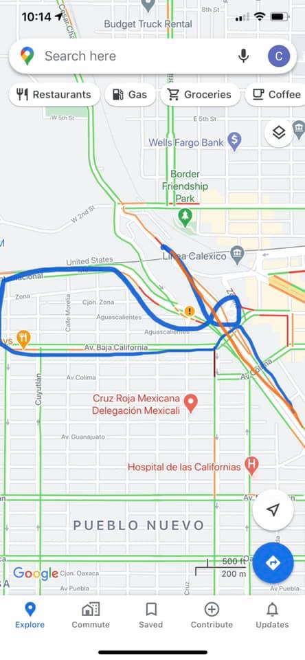
Christian you CANNOT take the red line. That is what I did. After that there are concrete barriers preventing you from getting in the "normal" line. Are you saying follow the blue?
yes. Red line takes you to sentri. Follow blue and you’ll hit Regular lane. There are signs.
Chuck yep did that too one time i was towing a boat so I couldnt get back over quick enough.
The boarder gate person was a hardass but got a really cool inspection guard and i got through inspection in 10 minutes.
https://web.facebook.com/groups/BajaRoads
[b]
Sooo from rio, the road that goes to Sentri, exit to the right just passing the first bridge. Then it goes up, then take a left. Stick to the right (as if you’re going west) and then a few streets down, you can enter the regular. Stick to the right again and do the loop, you’re there.
If you go straight at rio, passing under BOTH bridges, you’ll hit sentri and get fined.
Blue line is regular.
Orange is sentri.
under = bad
Chuck
yes you nailed it here. I see that fork. If you don't take the blue line, you are blocked in due to concrete barriers.
Christian it’s confusing, but once you do find it, it’s easy

Christian you CANNOT take the red line. That is what I did. After that there are concrete barriers preventing you from getting in the "normal" line. Are you saying follow the blue?
yes. Red line takes you to sentri. Follow blue and you’ll hit Regular lane. There are signs.
Chuck yep did that too one time i was towing a boat so I couldnt get back over quick enough.
The boarder gate person was a hardass but got a really cool inspection guard and i got through inspection in 10 minutes.

dean- Posts : 5621
Join date : 2008-01-01
 eastern Mexicali border crossing
eastern Mexicali border crossing
from facebook
https://www.discoverbaja.com/go/driving-directions/mexicali-east-border-directions/
here is printable
https://www.discoverbaja.com/wp-content/uploads/Mexicali-East-Border-Crossing.pdf
from facebook
From Hwy 5 turn right at the Kenworth sign. Follow that all the way to border wall turn right follow the road towards the entrance bypass the cars waiting in line. Go towards the truck crossing and make a u-turn one block. Then you'll get in the general lane. Hope that helps.
· Reply · 9h
Michael Sku
Stay in the right hand lane after the underpass on hwy5 the Kenworth sign is at the next light. I travel by land marks
https://www.discoverbaja.com/go/driving-directions/mexicali-east-border-directions/
here is printable
https://www.discoverbaja.com/wp-content/uploads/Mexicali-East-Border-Crossing.pdf
facebook wrote:
This link will take you to the Discover Baja directions to Mexicali East - very clear with pictures. I was even able to to to surface Google Maps, put the little man down on the streets and follow it. Pay attention to the very end where they explain that the approach to the actual lanes are as follows: The first sign is for general auto traffic, but there is a sign that says SENTRI that directs you just beyond the first turn-off. You will see two lanes on your right divided by concrete barriers. The first one is the "READY" lane and the one just to the left of it is "SENTRI". The following directions are VERY clear. Good luck.
One word of caution about the Discover Baja directions. These direct you from Hwy 5 so that you approach the crossing lanes from the East and make a right turn into them. If you're approaching from the West you will have to make a left turn against oncoming traffic which looks iffy and not sure how they are controlling this. I would follow the advice of Michael Skurka above and continue East to the left turn lane, make a U and come back to the lane entrances. CAUTION: Also be aware that making a left turn from the West will head you directly into the "SENTRI/READY" lanes only whereas the access to the general lane is a right-hand curve that you can only approach from the East.
dean- Posts : 5621
Join date : 2008-01-01
 Re: route From Mexicali, San Luis and Los Algodones HWY 5
from facebook for going north to avoid traffic two suggestions from people.
An alternate desert route would be to cut off the 10 at Palm Springs at the 62-247-15-58-5. The 58 now bypasses Kramer Junction so it’s a straight shot from Barstow to Bakersfield.
I live in NorCal cross at Mexicali East to 111 to 78 to 86 to 10 then 210 to 5 North. 210 skirts LA I always take this route. if you were to cross at Tecate you would be driving a longer distance having to back track to El Centro or be stuck going through the LA area.
dean- Posts : 5621
Join date : 2008-01-01
 San Luis and Los Algodones
https://af7kq.com/2017/02/18/mexican-border-formalities/
Mexican border formalities, San Luis and Los Algodones
also
mexicali crossing...
Mexican border formalities, San Luis and Los Algodones
also
facebook post wrote:I crossed over at San Luis and thought it much easier that Mexicali. No need to drive thru Yuma any longer. !95 south to San Luis is a piece of cake, very good road and the border is one block fm Hwy 2 to Mexicali. When you get off the 2 and on the 5, you have to make a right hand turn, go a block or two and make a U-Turn on 5 to head towards S.F...I think this is the easiest route and I was driving a 38ft Diesel pusher.
mexicali crossing...
facebook post wrote:Raul Goodman Yes but you can go by the 98 freeway. Any way Is just and advice. I live in Mexicali if you need something
dean- Posts : 5621
Join date : 2008-01-01
 Re: route From Mexicali, San Luis and Los Algodones HWY 5
if crossing San Luis
another description
facebook wrote: if you decide to take the San Luis toll rds. be careful at the second toll booth as you are forced to make a right turn but then have to do a uturn .. you'll be able to see the trucks from the toll doing it with no problem, then proceed under the concreate under pass to San Felipe... safe travels.. also do not drive these roads at night... toll rds are the safest...
another description
facenbook wrote: San Luis toll RD. there are 2 toll fees one at one end and the other as you take a weird turn to back track under an over pass... look for the sign to San Felipe
dean- Posts : 5621
Join date : 2008-01-01
 Re: route From Mexicali, San Luis and Los Algodones HWY 5
facebook wrote:Take road 8 out of Loa Algodones, west to ejido Lázaro Cárdenas, South to 6 west and it merges with 2 west. Funky turn around when you get to 5.
dean- Posts : 5621
Join date : 2008-01-01
 Re: route From Mexicali, San Luis and Los Algodones HWY 5
facebook wrote: Folks. We are heading south through Mexicali & hit 5 to San Felipe. Then on south to 1 and Mulege in mid Nov. what is a nice economical motel in San Felipe for a night. Thanks
Elizabeth blue sky before you get into town. just after 1st gas station on right.
s Drc El capitán downtown just one block from the malecon 500 pesos is like 29 dlls...not a great place but enough to spend one night
Sally On Highway 5 last motel on the left going out of town heading south. Clean and cheap. It is painted aqua green,think the name is San Francisco motel or similar. We've stayed there a few times. Nice views.
Ralph SGroup Moderator Sally, do yu mean hwy 5....and south or north of San Felipe.
Sally South of San Felipe, one of the last businesses on Hwy Five going out of San Felipe. Sorry I meant Hwy Five.
dean- Posts : 5621
Join date : 2008-01-01
 Mexicali east crossing to USA
mexicalli heading to USA, at 12 minutes is the important turn
at 14 minutes another turn
https://www.youtube.com/watch?v=_pIt_ehM6wg
http://www.mysanfelipevacation.com
https://www.youtube.com/watch?v=EP1JxTOarP0
at 14 minutes another turn
https://www.youtube.com/watch?v=_pIt_ehM6wg
http://www.mysanfelipevacation.com
Since early 2014, the highway from San Felipe - Mexicali has been in great shape as all road construction has been completed. You can easily complete the drive in 2 hours maximum.
Video filmed starting in San Felipe by the arches in downtown and cruising along the San Felipe - Mexicali Highway 5 all the way to the US - Mexico border (Calexico-Easter border crossing).
http://www.cbp.gov/contact/ports/cale...
The Video includes important tips that will get you to the new border crossing in Mexicali, popularly called "Calexico East."
We recommend you take the Calexico East border crossing because it generally has less wait times than "Calexico West". Of course, if you want to shorten wait times to the barest minimum, then best to get the border by 8AM, or after 8PM.
From San Felipe to Mexicali, you will be travelling on Highway 5. It's difficult to get lost here, however, when you get to Mexicali, there are a few turns you want to be aware of. Especially if you plan to use Calexico East crossing.
First important turn is to make sure you make a right turn right after the Kenworth dealership in Mexicali. There is no good road sign alerting you to make a right for the border, but watch the video and make a mental note.
TIP: Once you get on to "Calzada Abelardo L Rodriguez" avenue, you will be driving along the border fence. Stay within the traffic limits here as Mexican cops are known to frequent this road and catch speeding motorist. tendency
https://www.youtube.com/watch?v=EP1JxTOarP0
dean- Posts : 5621
Join date : 2008-01-01
 mexicali west crossing into mexico
https://www.youtube.com/watch?v=BlH8nM31uLA
dean- Posts : 5621
Join date : 2008-01-01
 Re: route From Mexicali, San Luis and Los Algodones HWY 5
5-1 south of Gonzaga bay
I have read that they are allowing depending on the construction for people to take most of the unpaved new road except the middle section, pleaople have reported being able to drive it in a pick up truck in about 1.25 hours. Still not great for trailers.... or big RVs.
I have read that they are allowing depending on the construction for people to take most of the unpaved new road except the middle section, pleaople have reported being able to drive it in a pick up truck in about 1.25 hours. Still not great for trailers.... or big RVs.
favebook wrote: So most people are going to cross during the day and get to at least San Filipe depending on how long they've been driving before they hit the border. If you go early AM, you can easily do Border to Guerrero Negro in about 8 hours. From San Filipe, it's 6 hours.
dean- Posts : 5621
Join date : 2008-01-01
 Re: route From Mexicali, San Luis and Los Algodones HWY 5
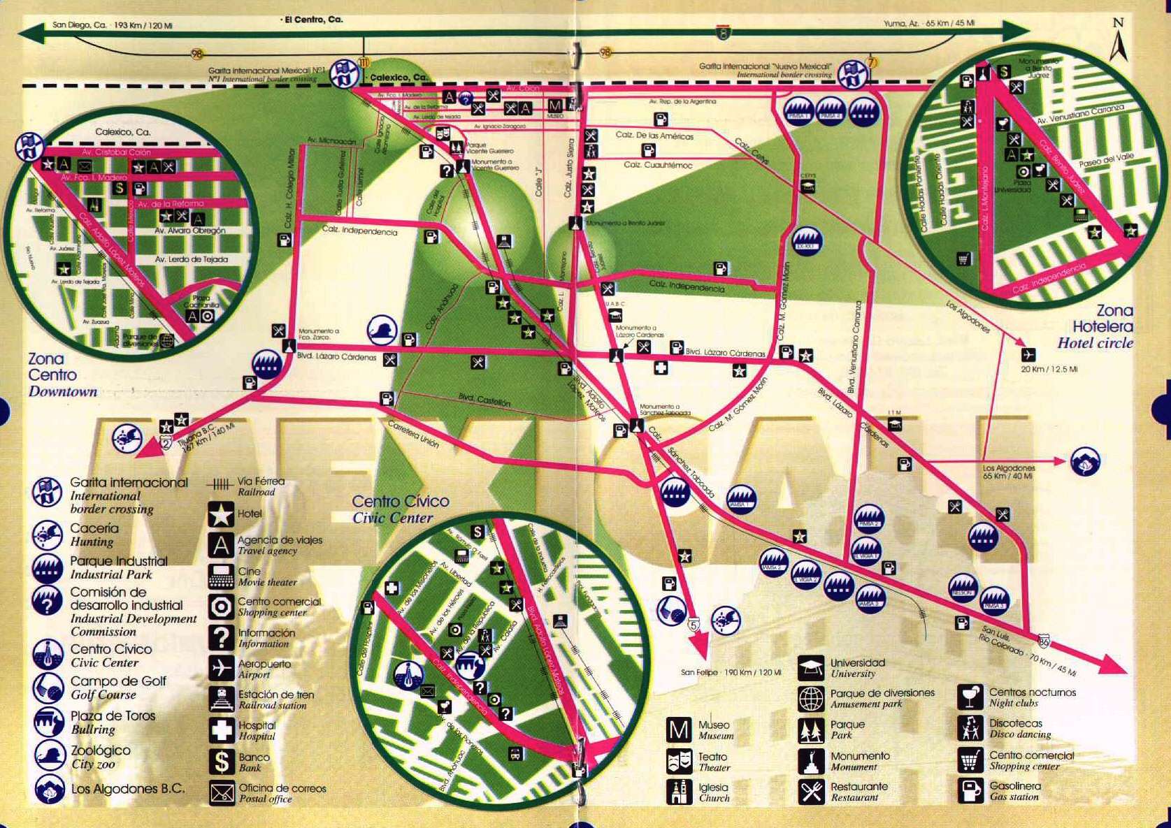
http://www.baja-web.com/mexicali/mxl-location-map.jpg

dean- Posts : 5621
Join date : 2008-01-01
 Re: route From Mexicali, San Luis and Los Algodones HWY 5
facebook post wrote:
San Filipe - Hotel de Los Angeles South end of town before the marina BIG 3 story building GREEN with yellow accents. Have kitchenettes, decent wifi, ocean views about $600 p a night
Guerrerro Negro : TerraSAL (not sol) edge of town off the Hwy. Has a nice restaurant on site. $650 p per night
Mulege: Hotel Serenidad - South edge of town off the hwy (not downtown) Funky cool place from the 50's Has pool, restaurant, etc about $1200 p per night
Constitutcion - Mumbi - South edge of town just on the outskirts (right side you will pass some industrial bldgs like one of the beer companies) has parking garages for your vehicle. about $900 p per night
La Paz - Hacienda del Sol - Inner Bay, just down the road from the PeMex at the 3 points. Studios - 2 bedroom casitas, pool, walk to the Bay not sure on the nightly rate (info@hacienda-sol.com )
in Mexicali main road near smart and final and costco 600 pesos
http://hotelalamosposada.com/en/habitaciones-y-tarifas/
Blvd. Benito Juárez No. 4257
Ex-Ejido Coahuila
Mexicali, B.C. 21360
Teléfono: (686) 563-3223
hotelalamosposada@hotmail.com
Hoteles Posada
Hotel Alamos Posada
Hotel Posada del Sol
Hotel Posada Inn
Last edited by dean on Tue Oct 10, 2017 9:10 pm; edited 1 time in total
dean- Posts : 5621
Join date : 2008-01-01
 Re: route From Mexicali, San Luis and Los Algodones HWY 5
Recently may 5 did the up there and later back via 5. Stopped at san Felipe for an overnight heading back at a budget place about USD$35.00, don't take your wife there, it did have hot water. Here are the gps co-ordinates. 31.031432, -114.836948
the dirt road seemed better than before. the paved road going north near the turn off from GN to the dirt road was horrible with pot holes, really bad.... But on the way back it was not nearly as bad 10 days later so they do do some road work.
The good news as I mentioned it seems they have made the dirt road better, but the bad news to me that means they do not intend on it being finished for a long time. They could almost pave 10-14 miles of it right now if they just finished a couple little effort parts. But it kind of seems they are going to wait till they have the mountains smashed open. This could be about 5 years is my projection. Again hoping they pave about 14 miles. Boy that would make it real doable to only have 8 miles of crawl for 5 years or so, that is the part that is still the slowest section. Mexicali crossing going north was a headache, Saturday 6pm is when I arrived there, about 2 hours at least it was not hot.
I also crossed at San Luis, AZ coming back. They are very vigilant at this crossing checking cars for duty items, glad I went in the declare lane to the far left. Traffic was heavy, probably took me longer to get to the border here than all my years of crossing, nogales, tecate, Otay, and TJ. Traffic was backed up big time entering mexico, about 20 minutes before you get to customs. So I went in the declare and boy were they tough. I had the receipt on my 3D printer for USD$229.00 and had to get it on my computer because it was mail order. She wanted to charge me for the shipping too and each spool of printing material, but I told them here is my receipt which I got the spools free. She said they did not care, i had to pay duty on like USD$600.00. So I politely asked for her supervisor who had told her to look for the 3D printer material. Pretty sharp guy, his english was spectacular and both of their professionalism was spectacular. But they were going to charge me duty for too much. So he came over and went through my other things. things were already out as she had me unload the car, which takes nothing to reload it. Now he ran into some other things I was bringing down for making mosquito traps and research and asked me to explain. I told him I invented a new mosquito trap and that is also why I was bringing the printer, he asked me what my profession was, I told him engineer. He then asked me for my website for the mosquito traps and he checked and they went and huddled. Again his communications in english were instantaneous no delay in understanding. He did not come back with her but she came back and said I could just pass now. And she wished me luck with the traps. They have the authority to allow me I think $300.00 of duty items for free if they desire. So I was on my way with not having to pay duty, plus because it is a printer they also have another latitude there because it is a 3D printer and computer items for personal are duty free too.
Took the 2 west from that AZ crossing to bypass Mexicali to get on the 5 very good road. Toll cost was low.
At many of the checkpoints heading south. i was alo inspected, i found that having a few dolls in the top part of the trunk for my 11 year old disarms them. As soon as the see them they stop searching and ask if i have a child. Man does that save a lot of time... Note to self once Sophia is over doll age take a few of her dolls with me up north for the return trip.
dean- Posts : 5621
Join date : 2008-01-01
 Re: route From Mexicali, San Luis and Los Algodones HWY 5
from facebook post may help out...
I go south on Rio nuevo, (just south of the POE, and then take Teran Teran. And bypass all the traffic. U will come out right by the mexicali Costco.
dean- Posts : 5621
Join date : 2008-01-01
 which exit at mexicali?
facebook wrote:Mexicali east. far left lane is Sentri. middle lanes for "ready lanes" (passport card), and far right 2 lanes for normal crossing.
dean- Posts : 5621
Join date : 2008-01-01
 Re: route From Mexicali, San Luis and Los Algodones HWY 5
Double Trip report (north and then south), as long as you can go slow for the 22 miles the going over to Gonzaga Bay is the way to go. (not a long/big rv rig or pulling a trailer IMHO) Also the 50 miles near south of San Filipe you need to go the speed limit because of the vados. I have a very low clearance car VW... and as long as you go slow you are fine on this hwy 5 construction area to hwy 1.. There is now diesel at Gonzaga Bay.
I also found driving the dirt part at night to be easier for me as I drive slower by human nature at night. And a side benefit is they are not working so you can drive on the 5-7 finished bridges and good pack areas for about 1/4 of the total distance on the east side.
Also a side note when on the final miles (maybe at 1 mile mark from hwy 1, on the west side there is a major un-intentional camouflaged tope where you want to be going about 30 mph but should be doing 10 mph and it did take out my oil pan, being a low clearance car.. Lost a day getting it band-aided that has worked for 3000 miles and the return voyage. I have a spare oil pan now. And spare oil.
Also note the 5-7 mile road construction approaching LaPaz is very similar to this entire 22 mile stretch, especially where the one near LaPaz gets very challenging in a few small runs that is what it is like about 7 miles of the bad areas of the 22 miles. and the rest of the 22 miles is like the mild parts of that construction are approaching LaPaz. So if that construction was nothing for you so will the 22 miles from hwy 1 to hwy 5.
Took me 2 hours to do it this time, did it before in 1.5 hours. I noticed on the first trip 10 days ago some workers fixing the old road we drive on a little bit with a front end loader and on the return yesterday those areas were better. still only 5mph in many areas and max was 20mph at the best areas for me with a low clearance car. Where I hit the nearly invisible tope and broke my oil pan, I was doing about 30mph hitting my brakes and probably hitting it it at 20 mph.
I look at it I now have a new friend mechanic at the hwy 1-hwy 5 junction that I will be visiting for the years to follow.. As side note his (jose luis) English is as good as ours, if driving by stop and drop off a few eggs, dog food for the many friendly dogs he has adopted or other items you may not need anymore, he does live in a rugged area, no cell/phone, water, gas, electric for 40 miles to Catavina which are outrageously priced. I am thankful he is there.
This shortcut is good because the entire side from mexicali is safer from serious issues is my experience of 3 times crossing it in the last year (less curves, less cows, less pot holes, less mountain grades with curves with trucks cheating into your lane and significantly faster, saving 2-4 hours even when I depart San Diego area. So if coming from the backside of LA or San Diego avoiding rush hour traffics, or heading north or east from Mexicali you save much more time. Plus it is rumored that there is construction traffic on hwy 1 past ensenada that can cost you 2 hours right now, and not a bombardment of traffic and lights and slow busses from ensenada to San Quintin.
Now a benefit there is a good smart and final in Mexicali right on the 5 highway, well a block off. The one in ensenada is horrible stopped there and no gringo foods. But this Mexicali one is huge and carries many gringo foods like cheeses. Like cheddar and pepper jack and so on. No USA meats. They carry a lot of products in bulk at great prices that you can buy on the mexican side and not have to deal with importation issues obviously. I would recommend when leaving baja just stopping there to see the items they carry for reference when you return next trip. .There is also a conveniently located COSTCO almost at the 2 and 5 junction.
Talking to the mechanic at the corner where the construction workers for the west end bridges are sleeping, this crew is to be finished with their bridges on the west end by the end of December. This is only the bridge work that this crew is working on, and then who knows if they will send in the crews for paving these sections till they are completely done which from what I can see in the center is a few years away from being done. If they just pave the far east and far west parts that are near finished with the bridges in those sections it could leave about 1/3 to be completed in the future and really make this route popular even just being 2/3 done. That 1/3 to be finished is the worst part too. But would bring it down to maybe 45 minutes or 7 miles of yuck. And again I think night driving it on the return made a huge difference, i had no wish to even go fast. for those of us that are impatient.
dean- Posts : 5621
Join date : 2008-01-01
 Re: route From Mexicali, San Luis and Los Algodones HWY 5
https://www.youtube.com/watch?v=jfJ1oUnYc6Y&feature=youtu.be
hwy 5 construction areas... 23 miles left area view.
Published on Mar 24, 2016

http://www.periodismonegro.mx/2016/03/30/en-2016-mexicali-conectara-directamente-con-transpeninsular/
In 2016 Mexicali connect directly to Transpeninsular
this says the road will be finished this year? this via goggle translate.
hwy 5 construction areas... 23 miles left area view.
Published on Mar 24, 2016
Aerial Views of Baja California Norte Mex 5 Construction. Video captured in mid March 2016. Also shown are some clips of Gonzaga Bay and the mountains and Sea of Cortez, north of San Filipe.
This video was primarily done for the purpose of showing the status of the Mex 5 construction zone. As you can see, it seems that most bridges and culverts are nearly done but there are still hills to knock through and flat sections of the new road that still needs to be blazed. The video has been sped up in some sections which accounts for some jerkiness.

http://www.periodismonegro.mx/2016/03/30/en-2016-mexicali-conectara-directamente-con-transpeninsular/
In 2016 Mexicali connect directly to Transpeninsular
this says the road will be finished this year? this via goggle translate.
They will be saved 4 hours from the capital you can travel to South Peninsula
This year SCT connect with Mexicali- Transpeninsular Highway Laguna Chapala
SCT press release
MEXICALI.-With the construction of five bridges and placing asphalt in 30.9 kilometers. This year will be achieved interconnect the Transpeninsular Highway with the road Mexicali- Laguna Chapala, stretch Puertecitos - Laguna Chapala.
During a tour of work by the southern state, headed by the Director General of the Center SCT Baja California Padrés Alfonso Pesqueira, could see the progress of the work.
He explained that investment in 2016 will be about 290 million pesos, with resources hundred percent of the Government of the Republic.
Transpeninsular1The length of the bridges to build varies according to the characteristics of the basin.
The first structure is designed to 32 meters in length, The You drag VI is 80 meters, Turquoise I and II will have a length of 65 meters and 108 meters Laguna Chapala bridge.
the asphalt will also place since 2015 works were carried out earthworks, as a strategy to move forward and seize the equipment required to breach as inhospitable as it is the desert of Baja California land.
Pesqueira said Padrés have confidence in the tourism and economic growth corridor Sea of Cortez, this new road also be a new option to reach the northern border, savings of up to 4 hours generated.
Transpeninsular3"At the beginning of the administration was the indication Move to Mexico, achieving the objective esteremos build roads that generate greater security and contribute to the free movement of people," said the Head of the Center SCT, BC
dean- Posts : 5621
Join date : 2008-01-01
 route From Mexicali, San Luis and Los Algodones HWY 5
BPE
We drove the route From Mexicali to the East Cape in November. It was lovely to avoid all the freight trucks and congestion between Ensenada and El Rosario.
The road south of San Felipe is old, but paved; be cautious of speed, as some of the dips are pretty exciting.
From Puertecitos to Bahia San Luis Gonzaga (and Alfonsina’s) it’s new pavement and quite good. There’s a short, few kM, section still unpaved from the end of pavement to Gonzaga. Alfonsina’s a historic stop on this route and has good clean rooms and good food.
From Gonzaga to Mex 1 is 30(?) miles of rough rocky road, with the last 8 miles being the worst. Our traveling friend got two flats at the same time on his F150. Good news is that there’s a llantera where this road intersect Mex 1. Plan on 2 hours. You should stop at Coco’s Corner on the way out and have a beer with the legendary Coco. You might be wise to disconnect the dune buggy and drive it thru this section. We drove a 2006 Subaru Outback with no problem. When we return north in a couple weeks, we’ll take the same route. Buena suerte. Ron
Last edited by dean on Wed Jan 03, 2018 4:15 am; edited 2 times in total
dean- Posts : 5621
Join date : 2008-01-01
 Similar topics
» video of Loreto to Mexicali in fast motion
» San Luis crossing
» HW1 cut to san filipe then to mexicali
» heard this yesterday
» Aduana/Banjerco get a car TIP pass in Mexicali MAP
» San Luis crossing
» HW1 cut to san filipe then to mexicali
» heard this yesterday
» Aduana/Banjerco get a car TIP pass in Mexicali MAP
Page 1 of 1
Permissions in this forum:
You cannot reply to topics in this forum
